
How to Use the Interactive Map of Japan
A clear walkthrough of the Interactive Map of Japan: start with the country view, travel deeper into prefectures, use category layers and location cards, save the places that matter, and turn them into a practical trip.
Affiliate disclosure: Some links in this article may earn Japan Trip Planners a commission at no extra cost to you. Recommendations are included when they are genuinely useful for planning, and you should still compare current prices, terms, and official provider information before booking.
Start with the Japan Map when you need the big picture
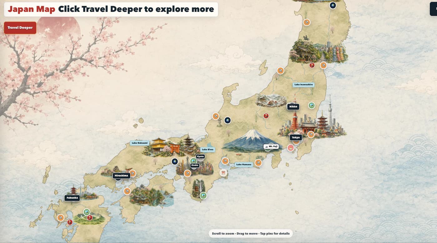
Open the Interactive Map of Japan when you are still deciding where a trip should go. The opening Japan Map is designed for orientation: it shows the country as one connected journey, with major cities, attractions, airports, stations, nature, and other useful planning points in their real geographic relationships.
Start with a question. You might be choosing an arrival city, looking for a day trip near Kyoto, comparing an airport route, or deciding whether a region deserves an overnight stay. The map works best as a way to narrow a trip into sensible areas before you fill a calendar with individual stops.
When a place interests you, select its pin to see its name, category, prefecture, short planning description, and any available links.
Use Travel Deeper to move from Japan to a prefecture
Select Travel Deeper when you want to choose a region or compare the country's 47 prefectures. The prefecture view makes it easier to see the different travel personalities across Japan: a dense urban base, a mountainous driving region, an island itinerary, a rail-friendly corridor, or a slower coastal escape. Use the fast-travel options when you already know you are heading toward a major place such as Tokyo, Kyoto, Osaka, Hiroshima, Fukuoka, Okinawa, or Hokkaido.
Click a prefecture to open its individual map. This is where the map becomes most useful for day-level planning. You can zoom much further into the area, see the places that actually belong in that prefecture, and explore attractions, temples, museums, parks, trains, beaches, onsen, restaurants, and lesser-known stops without the rest of Japan competing for attention.
Use the Back to Prefectures Map control when you are ready to compare another area. If you have traveled far from the center while exploring an individual prefecture, use the recenter control to return to that prefecture's useful starting view instead of losing your place.
Turn on the map layers that answer your planning question
The left map sidebar is your filter panel. Use its toggles to show or hide Popular Cities, Must-See Attractions, Airports, Temples & Shrines, Castles, Museums, World Heritage, Nature, Parks, Beaches, Roads, Lakes & Rivers, Volcanoes, Major Stations & Routes, and the other available layers.
For example, use Major Stations & Routes and Airports when you are shaping arrival, departure, or intercity movement. Use Temples & Shrines, Museums, Parks, and Must-See Attractions when you are filling a city day. Use Nature, Beaches, Lakes & Rivers, and Volcanoes when you are deciding whether a rental car, weather buffer, or overnight stay makes sense.
Some specialty databases are Premium features. The map still tells you how many locations are available in those categories, so you can understand the depth of the collection before deciding whether Premium suits the way you plan.
Search by prefecture or jump directly to a place
Select a layer label or its icon in the sidebar to open its location browser. Each list is grouped by prefecture, so you can quickly find the right part of Japan without manually scanning the map. Use the search field at the top of the browser to narrow the list by prefecture, city, or location name, then select a result to fast travel to that pin.
This is particularly useful when you have heard a place name but do not know where it sits: a shrine in Kyoto Prefecture may not be in central Kyoto; an onsen in Gunma may be a long drive from Tokyo; a beach near Fukuoka may work better as a coastal day than a city morning. The map gives you context before you build a route around a name alone.
On larger prefectures and island regions, use the Fast Travel panel to move toward key areas without dragging across long distances. Tokyo opens around central Tokyo, Okinawa opens around the main island, and selected wide regions include their own practical area shortcuts.
Open a location card, then save the ideas worth keeping
Select a pin to open its location card. The card gives you a concise reason to visit, its category, its city and prefecture, and relevant next steps when they are available, such as a booking, guide, video, or related blog post.
Use Save Place for the locations you genuinely want to keep considering. Saved Places remain connected to your account, so the same collection can appear on another device after you sign in.
A saved place is still an idea, not an itinerary event. Before assigning it to a day, look at the surrounding locations, the transport needed, time at the attraction, and the rest of the route.
Use the map to build better itinerary days
The strongest workflow is simple: collect places on the Interactive Map, group the ones that are actually near each other, then bring only the best candidates into the Itinerary Builder.
Open the Itinerary Builder when you are ready to put an idea on a specific day. The Saved Places area in the itinerary sidebar lets you reopen your map collection while you work. Add a specific event title, give it an honest time window, and include any ticket, reservation, station, hotel, or reminder details you will need later.
The map and itinerary are deliberately different tools. The map is for discovery, comparison, and geographic awareness. The calendar is for the commitment of a real day.
Plan confidently, then confirm the live details
The Interactive Map is expanding continuously, but it is not a claim that every destination in Japan is represented or that every operating detail is permanent. New pins, guides, routes, images, and booking links are added over time. If you spot a missing place, an inaccurate detail, or a useful improvement, use the feedback link on the map to send it through.
Before you travel or book, confirm opening hours, closures, weather conditions, accessibility, age rules, reservation requirements, transit schedules, road access, and the official provider's current price. This matters most for mountains, volcanoes, seasonal cruises, caves, ferry routes, onsen, temporary exhibitions, and attractions that sell timed tickets.
Used thoughtfully, the map becomes a better kind of travel research: visual enough to inspire you, structured enough to keep the route sensible, and connected to the calendar where your final trip takes shape.
Travel details can change. Confirm current schedules, opening hours, reservation rules, prices, and entry requirements with the relevant official provider before booking or traveling.